Winter LiDAR surveys in forested Areas: timing and software make the difference
Winter is the best season for airborne LiDAR surveys in deciduous forests. Leaf-off conditions improve ground detection, but sensor choice and data processing software make a real difference in the final result.
Paolo Corradeghini
10/25/20252 min read

We’re about to enter the most favorable season for using airborne LiDAR sensors (mounted on drones, airplanes, or helicopters) to survey forested areas.
Or at least deciduous forests (the ones that lose their leaves).
We’re not quite there yet.
Where I live, most of the leaves are still on the branches.
I believe the best period runs from December to April.
But it also depends on latitude, temperatures, and elevation.
Some areas start earlier, others a bit later.
LiDAR, by its nature (because it’s an active system that sends laser pulses into space looking for something to hit) and by the way it works (because it emits thousands of pulses while moving), is well suited to studying the ground beneath forest canopies.
And if the trees are leafless, it works much better!
There are many different sensors.
They vary in range, number of returns (how many times a pulse is recorded after being reflected multiple times during its path), type of emitter (solid-state, rotating scanner), platform (drone, airplane, helicopter), and price.
Not all of them perform equally well everywhere.
The one I used before, for example, struggled a bit to “find its way” through summer forests.
And it wasn’t the only one.
(Spoiler: if someone told you that all LiDAR systems penetrate vegetation and always reach the ground in any condition or season, that’s not exactly true…)
In winter, though, they are very effective.
Even if daylight hours are shorter.
But a LiDAR sensor alone is not enough.
You also need good software to process the data it collects.
If you want to extract ground points from a point cloud that also contains trunks, branches, houses, cars, and power lines, it’s worth thinking carefully about the software side as well.
Software can make a huge difference in terms of “hours spent in front of a monitor staring at colored dots in 3D space”!
Choosing the ideal boundary conditions for a LiDAR acquisition (and this applies to most data acquisition workflows) helps you collect as much information as possible from that environment.
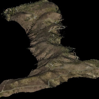
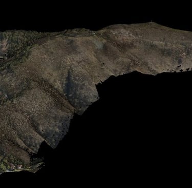
In the case of the images I’m sharing, once the ground points are extracted from the point cloud, you can clearly see footpaths, logging tracks, and small trails along the slopes.
Artificial Intelligence is entering through the front door of commercial software that manages these datasets, especially for segmentation and classification.
And I believe it will become more and more present.
Even if, for now, human expertise has not yet been replaced.
🙂